








Verified on
Cambodia transport map
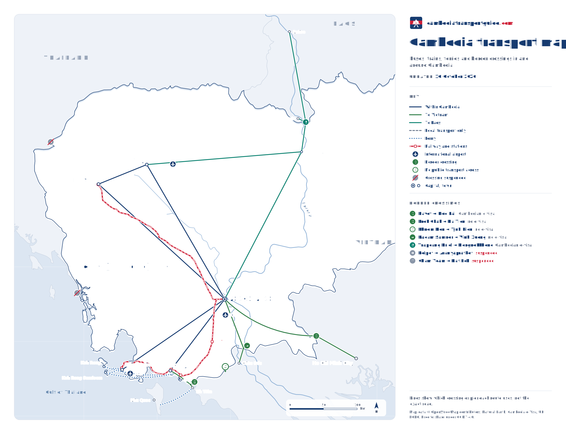
One map of the buses, trains and ferries this site covers, Cambodia's three international airports (KTI, SAI, KOS) and its main border crossings, each marked with whether Cambodia's e-visa works there. Land crossings to Thailand are suspended, so they are shown greyed out. Tap the map to open it full size; it is free to share.
What the map shows
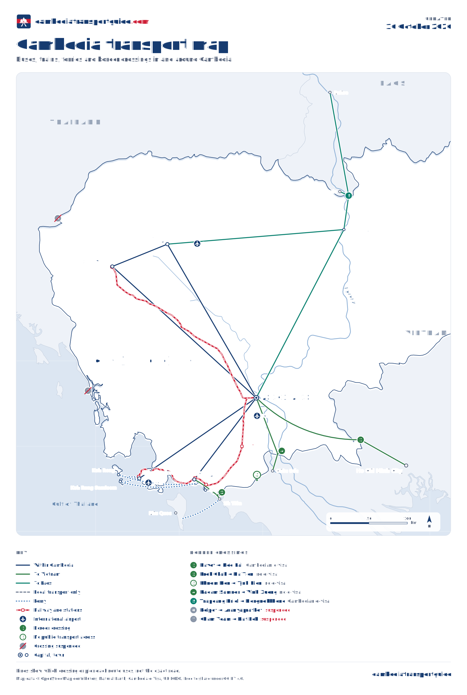
Routes. Dark blue lines are the bus connections inside Cambodia covered on this site: Phnom Penh to Siem Reap, Sihanoukville, Kampot and Battambang, and Siem Reap to Battambang. Green lines run to Vietnam, through Bavet to Ho Chi Minh City and through Prek Chak to Hà Tiên; teal lines run north through Stung Treng to Laos.
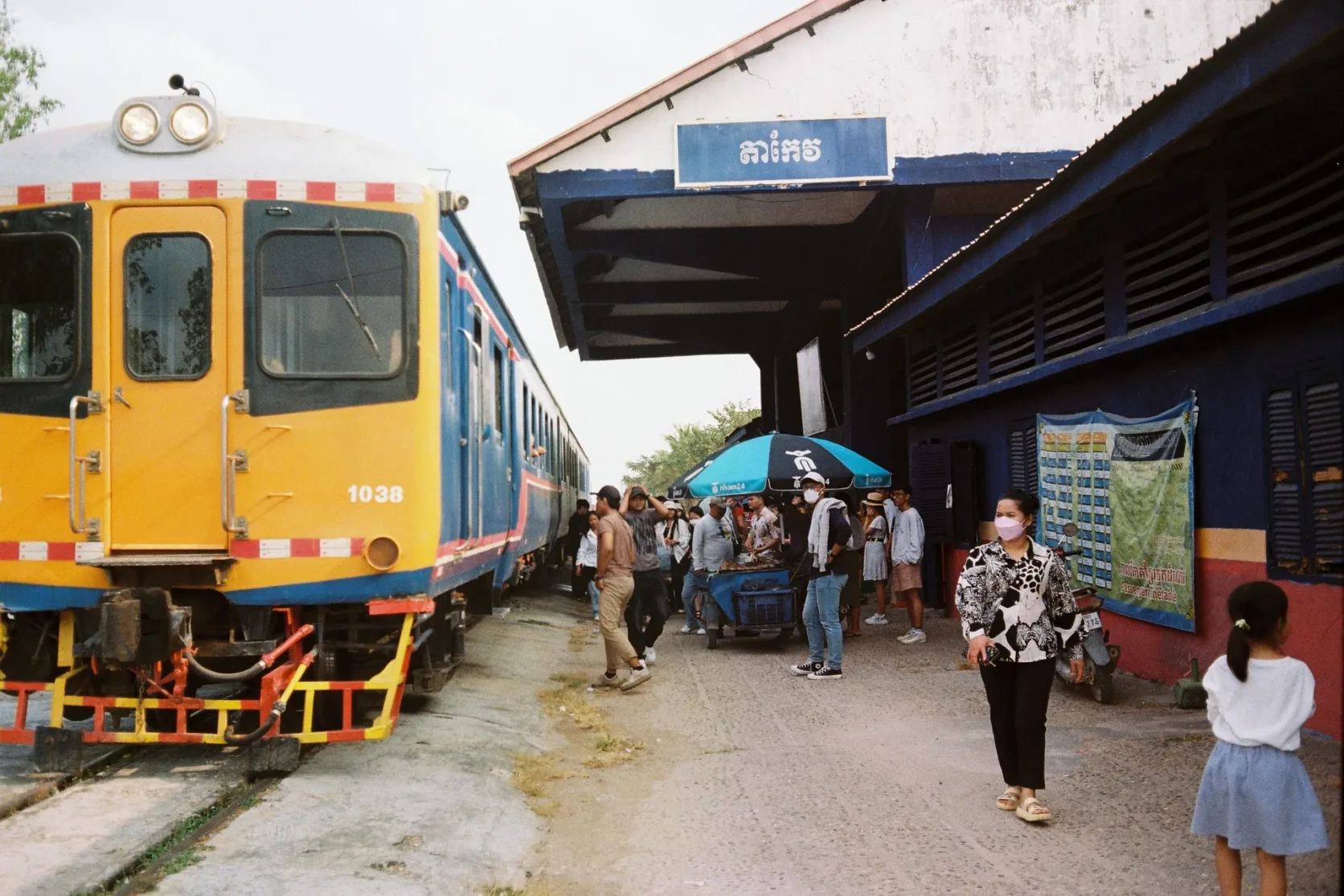
Railway. The red line is Royal Railway: the southern line from Phnom Penh through Takeo, Kep and Kampot to Sihanoukville, and the northern line to Battambang. See the train guide for times and tickets.
Ferries. Dotted blue lines are the speed ferries to Koh Rong and Koh Rong Samloem, from Sihanoukville and from Kampot, and the boat from Hà Tiên to Phu Quoc in Vietnam.
Airports. The plane symbols mark Techo International Airport (KTI) south of Phnom Penh, Siem Reap Angkor International Airport (SAI) and Sihanoukville International Airport (KOS).
Border crossings on the map
| Crossing | Cambodian e-visa | Status | Checked | Source |
|---|---|---|---|---|
| 1 Bavet ↔ Mộc Bài | Accepted | Open | 16 October 2026 | Cambodia Ministry of Foreign Affairs: e-Visa entry ports |
| 2 Prek Chak ↔ Hà Tiên | Not accepted | Open | 16 October 2026 | Cambodia Ministry of Foreign Affairs: e-Visa entry ports |
| 3 Phnom Den ↔ Tịnh Biên | Not accepted | Open | 16 October 2026 | Cambodia Ministry of Foreign Affairs: e-Visa entry ports |
| 4 Kaoam Samnor ↔ Vĩnh Xương | Not accepted | Open | 16 October 2026 | Cambodia Ministry of Foreign Affairs: e-Visa entry ports |
| 5 Trapeang Kriel ↔ Nongnokkhene | Accepted | Open | 16 October 2026 | Cambodia Ministry of Foreign Affairs: e-Visa entry ports |
| 6 Poipet ↔ Aranyaprathet | Not accepted | Suspended | 16 October 2026 | UK FCDO: Cambodia travel advice |
| 7 Cham Yeam ↔ Hat Lek | Not accepted | Suspended | 16 October 2026 | UK FCDO: Cambodia travel advice |
"Cambodian e-visa" says whether Cambodia's e-visa is accepted at that crossing for entry, as listed by the Ministry of Foreign Affairs. It does not say which other visas work there: at a crossing where it is not accepted, you need another kind of visa, and the Cambodia visa guide explains the options. Leaving Cambodia, every crossing in the ministry's table is marked for exit.
Which crossing for which trip
- 1, Bavet–Mộc Bài, is the crossing on the Phnom Penh to Ho Chi Minh City road. Giant Ibis and other companies run through buses that stop for both sets of formalities; see Phnom Penh to Ho Chi Minh City.
- 2, Prek Chak–Hà Tiên, is the coast crossing. Vans from Kampot reach it in 1 to 2 hours, and Kep is closer still; from Hà Tiên, boats run to Phu Quoc. See the Kampot and Kep guide.
- 3, Phnom Den–Tịnh Biên, and 4, Kaoam Samnor–Vĩnh Xương, are the Mekong delta crossings near Châu Đốc. VietnamTransportGuide found only minivans on sale between Châu Đốc and Phnom Penh for October 2026, taking about 7 to 9 hours 30 minutes.
- 5, Trapeang Kriel–Nongnokkhene, is the only crossing with Laos. Buses and vans from Siem Reap and Phnom Penh run north through Stung Treng to Pakse and the 4,000 Islands, changing vehicle at the border. The Lao side publishes opening hours of 06:00 to 18:00; check Lao visa rules before you go. See the Cambodia–Laos border guide.
- 6, Poipet–Aranyaprathet, and 7, Cham Yeam–Hat Lek, are suspended, like every land crossing between Cambodia and Thailand. Fly, or go overland through southern Laos; see the Cambodia–Thailand border guide.
Using and sharing the map
The lines show which crossing or pier each route uses, not the exact road, so use the map to plan the order of a trip and the route pages for times and fares. Tap the map to open it full size; on a phone you can then pinch to zoom.
The map is free to share and embed under a Creative Commons Attribution 4.0 licence; please credit CambodiaTransportGuide.com and link to this page.
Download the data
The crossings and lines on the map are available as data, for anyone who wants to reuse or check them:
- Border crossings as JSON and as CSV: position, status, Cambodian e-visa acceptance, check date and the official sources for each crossing.
- The whole map as GeoJSON: crossings, airports, piers, stations, towns, connections and the railway, ready for a GIS tool or a web map.
- The map itself, in portrait and landscape.
Positions in the data come from OpenStreetMap, so the files are under the Open Database License: credit "© OpenStreetMap contributors" and CambodiaTransportGuide.com.
How this map is made and kept current
- Places. Each town is its OpenStreetMap place node, checked against its Wikidata coordinate. Stations, ferry piers, airports and border posts are OpenStreetMap objects; Trapeang Kriel uses the position LaosBusTickets verified against satellite imagery. Borders, coast and rivers are from Natural Earth.
- Status and e-visa. Crossing status follows the UK Foreign Office's travel advice for Cambodia; e-visa acceptance follows the Cambodian Ministry of Foreign Affairs' port table. The table gives the date of both.
- Lines. A line is drawn only for a connection that a page on this site states, with its source. The map is regenerated from the same data every time the site is updated, and the weekly check of this site re-reads the travel advice, the e-visa port list and the operators' timetables.
- Changes. 16 October 2026: map published, with 7 crossings, 3 airports, the two railway lines and 16 connections, including the new speed ferries from Kampot to Koh Rong and Koh Rong Samloem.